PHASE II Plan Released January 2018
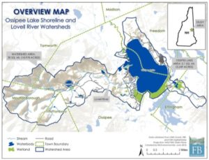
A Watershed Plan for the Ossipee Lake Shoreline and Lovell River Watersheds
The Ossipee Lake Watershed Management Plan provides a road map for preserving the water quality of Ossipee Lake, and provides a mechanism for procuring funding (e.g., Section 319 grants) to secure actions needed to achieve the water quality goal. USEPA requires that a watershed plan (or an acceptable alternative plan) be created so that communities become eligible for watershed assistance implementation grants.
As part of the development of this plan, a build-out analysis, water quality and assimilative capacity analysis, and volunteer shoreline/watershed stormwater surveys were conducted (Section 3). Results of these efforts were used to run a land-use model, or Lake Loading Response Model (LLRM), that estimated the historical, current, and projected amount of total phosphorus being delivered to the lake from the watershed (Section 3.3.2). An Action Plan (Section 5.2) with associated time frames, responsible parties, and estimated costs was developed based on feedback from community members that attended the public forum in June 2016.
CLICK HERE to refer to the published plan for the study process, the analysis, and the recommendations for future water protection projects.
CLICK HERE for the Phase II Appendices
CLICK HERE for the Ossipee Lake Water Quality Analysis (1976-2016) (released April 2017)
PHASE I Plan: Released March 2015
For the Ossipee Lake Lower Bays and Danforth Pond Subwatershed Management Plan*
The Ossipee Lake Watershed Management Plan Phase I is a scientifically-based plan that provides decision makers and local residents the tools needed to protect the water quality of these lakes for future generations.
CLICK HERE to download the Phase I document.
CLICK HERE to download the Phase I Appendices.
CLICK HERE to download the Freedom-Ossipee Build-out Report
John Shipman of Freedom reports on the Planning and Land Conservation break-out group discussion.
On July 12, 2014, F.B. Environmental and GMCG hosted a public forum in Freedom NH, to present the watershed findings to date, and to conduct small group interactive sessions with the objective of identifying and prioritizing watershed actions. About 40 local residents attended. CLICK HERE for the presentation provided by F.B. Environmental, including an update on the Lower Bays and Danforth Pond, Watershed Modeling, Shoreline Survey and next steps.
The second half of the morning, the participants split into 4 groups: Group 1: Roadways and Septic Systems; Group 2 – Shorefront Residential; Group 3 – Planning and Land Conservation; Group 4 – Water Quality Monitoring. Each group was asked to identify and list the threats to the watershed, and suggest actions they think are needed to address the threats and to preserve the values that the Ossipee Lake Lower Bays and Danforth Pond provide to the community and residents of the watershed? Each group was asked to prioritize the suggested actions with guidance from the facilitators.
The small interactive break-out group sessions results are posted here:
- Threats to the Lower Bays
- “Roads” discussion group suggested actions
- “Septic” discussion group suggested actions
- “Shorefront Residential” discussion group suggested action items
- “Planning and Land Conservation” discussion group suggested action items
- “Water Quality Monitoring” discussion group suggested action items
- Summary of the Threats and Actions
- Combined Actions Report
The drafted phase I complete analysis and written report will be forthcoming in the fall.
*Funding for this project was provided by a Watershed Assistance Grant from the NH Department of Environmental Services with the Clean Water Act Section 319 funds from the US Environmental Protection Agency.
September 2013
Volunteers assist in a Successful Shoreline Survey
On September 28, Watershed Management Plan Steering Committee members, dedicated volunteers and FB Environmental conducted a shoreline survey of the lower bays of Ossipee Lake (Broad, Berry, and Leavitt) and Danforth Pond. The purpose of conducting this shoreline survey is to gather information about development along the shoreline areas of these waterbodies. In particular volunteers looked at shoreline erosion and the extent of vegetated buffers on shorefront lots. This was not a regulatory survey but is instead providing information to help assess the condition of the waterbodies for the upcoming watershed plan.
Three boats departed at 9:00 am from different Bays with volunteers, data sheets, cameras, GPS units and binoculars. The weather was perfect for spending a long day on the water. Each boat evaluated every property in their assigned bay, slowly moving along the shore locating sources of soil erosion and polluted runoff that have the potential to damage lake water quality. The day was a complete success with all areas covered and all boats docking around 4:00.
Lakes are polluted, in great part, by non-point source (NPS) pollution in the form of eroded soil and the nutrients (phosphorus) it carries. As storm water flows over bare or loose soil, these pollutants adhere to water molecules and are deposited in water bodies such as lakes, streams and oceans.
There are many inexpensive ways to mitigate storm water runoff. Some simple actions that homeowners can do include:
- Prevent soil erosion – re-seed areas of bare soil. Plant trees, shrubs, and groundcovers to reduce the size of your lawn and absorb excess nutrients.
- Reduce or eliminate the use of phosphorus in fertilizers. Use phosphorus-free fertilizer if you must fertilize, and consider alternatives such as spot treatments, lime or compost.
- Maintain your driveway and camp road by re-grading and crowning regularly to keep the water off the road. Sediment washed from the road surface or ditches usually ends up in the lake.
For more information on the Watershed Management Plan or to volunteer, please contact GMCG at (603) 539-1859.
Funding for this project was provided in part by a Watershed Assistance Grant from the NH Department of Environmental Services with Clean Water Act Section 319 funds from the U.S. Environmental Protection Agency.
GMCG is working with the Department of Environmental Services, a watershed steering committee, and project partners to develop the first phase of a watershed management plan for Ossipee Lake. The initial phase will include a scientific assessment and recommendations for limiting nonpoint source pollution of surface waters in the Danforth Pond watershed and the subwatershed of the lower bays of Ossipee Lake. The project will include a training for community volunteers to conduct a watershed survey, and GMCG is presently seeking interested volunteers who would like to help out with this fun and engaging survey work in your area of the watershed. If you would like to volunteer to help survey in your area of the watershed, please sign-up by emailing us at info@gmcg.org.
GMCG hosted a great Watershed Management Plan kick off meeting July 24, 2013 in Freedom with 40 people in attendance and two great presentations by Trish Garrigan from EPA Boston and Forrest Bell from Portland. The audience was very engaged too and it set a very positive stage for this project. (Plus there were two state reps there and our partner from NH DES so a very well connected audience!).
Click here to review the presentation made by Forrest Bell on July 24, 2013.
We also want to share the 10 Year WQM Data presentation from Michelle Daley’s student at UNH, Melissa Cripps. The presentation has some wonderful graphs of the GMCG data and sets a good stage for the start of putting together our 10 year report on Water Quality Data that we will give to municipal officials. Corey Lane will be working on this report with both our partners at UNH (Michelle Daley and Bob Craycraft) and Forrest Bell as he will be interpreting the data in preparation for the Watershed Management Plan. Our “Thanks” to Michele and Bob for their continued support of the GMCG Water quality monitoring programs.


